Wednesday, August 17, 2011


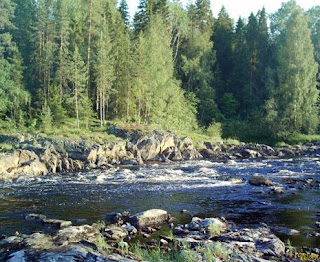
Republic of Karelia
Is one of the republics of Russia, the autonomous and has an area of
180.5 thousand square kilometers and is bordered to the west and Finland to the north province
Murmansk.
And a population of 772 thousand inhabitants, of whom 73.6% Russians, 13.1%
Indigenous population, such as the Finns and Alcarrilaon Alphipps and others also live in
Republic, a lot of other nationalities from all over the former Soviet Union.
There are 13 cities in Karelia and more than 800 villages and larger cities are
Petrozavodsk (282.5 thousand people), and Kondopoga (36.6 thousand people
And Sagija (35.8 thousand inhabitants), and Kostomocksha (31.5 thousand people. A
The number of Muslims in Karelia more than 20,000 people who make up about 2%
Of the population in the capital, and they belong to various nationalities of Azeris
And Talish and Tartars and Turks and towel and Afar and Dargan and Ezgin and Uzbeks, Tajiks
The Kyrgyz, Russians, Finns and Carrilaan and others.
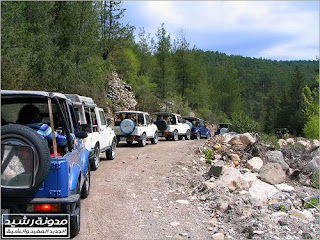
Cities and villages of the Republic of Karelia
Balomorsk, Kim, Kondopoga, Kostomocksha to Akhaddnpokhaaa, Mdwijigorsk,
Olunts, Petrozavodsk, Petkiaranta, Bodog, Sgja, Sortava
These are some of her images
180.5 thousand square kilometers and is bordered to the west and Finland to the north province
Murmansk.
And a population of 772 thousand inhabitants, of whom 73.6% Russians, 13.1%
Indigenous population, such as the Finns and Alcarrilaon Alphipps and others also live in
Republic, a lot of other nationalities from all over the former Soviet Union.
There are 13 cities in Karelia and more than 800 villages and larger cities are
Petrozavodsk (282.5 thousand people), and Kondopoga (36.6 thousand people
And Sagija (35.8 thousand inhabitants), and Kostomocksha (31.5 thousand people. A
The number of Muslims in Karelia more than 20,000 people who make up about 2%
Of the population in the capital, and they belong to various nationalities of Azeris
And Talish and Tartars and Turks and towel and Afar and Dargan and Ezgin and Uzbeks, Tajiks
The Kyrgyz, Russians, Finns and Carrilaan and others.
Cities and villages of the Republic of Karelia
Balomorsk, Kim, Kondopoga, Kostomocksha to Akhaddnpokhaaa, Mdwijigorsk,
Olunts, Petrozavodsk, Petkiaranta, Bodog, Sgja, Sortava
These are some of her images

Global tourism "a journey to the islands of Hawaii"
Global tourism "a journey to the islands of Hawaii"
Global tourism "a journey to the islands of Hawaii"
Global tourism "a journey to the islands of Hawaii"


Global tourism "a journey to the islands of Hawaii"
Global tourism "a journey to the islands of Hawaii"


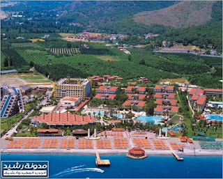
The most important tourist cities in Turkey
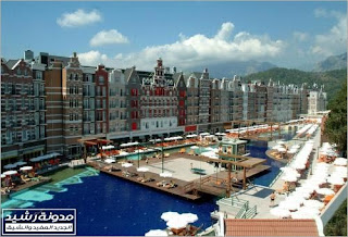
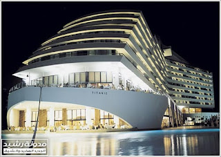
In this subject, which was attended by you for over a week you will learn the most important tourist cities in Turkey you will find on the subject General information about Turkey, aerial maps, important tips, Photo caption, the location of local tourism, some videos and we will review also pictures of all hotels (5 stars) in these cities so that there is a link to the website of each hotel so look at the fuller information and more images. If you want to increase your knowledge about Turkey or you are thinking of them travel for tourism or recreation, this topic will help you a lot.
General Information
Of course we known that every country is its own character in many ways, the piece must be certain we have the background for any country before traveling to, and the following points are points of clarification and a section of tips.
• Capital: Ankara
• Official language: Turkish (but can also English-speaking slots)
• Currency: Turkish Lira (and can deal with them in dollars or euros)
• Religion: Islam (99% Muslim, mostly Sunni and Alawite a section)
• Water: preferred not to drink tap water.
• Prices: not cheap especially in tourist areas. Beware of exploitation. (Example: liters of gasoline have the price of SR 7-8 This indicates that the cost of living)
• the nature of people: just like the Arabs in terms of external appearance, religion, their mood is hot and irritable. I mean, if entered the debate with a vendor over the price of a particular commodity may anger you and Atrdek.
• Food: East and familiar to us as Arabs.
• Hotel Rates: For example a journey 4 days, in the tourist season may cost you between 500-900 dollars, while in periods of "weak" might cost you between 250-500 dollars. Of course there are other factors that affected such as the cost of air travel (charter cheap) and the percentage of profit, the tourist agent. Preferred that the reduction in the local agent to take a clearer idea of the prices that may differ in each state.
• Prices at the airport in Antalya: Fantasy, pack a small Coca-Cola costs 40 riyals Saudi, and McDonald's meal costs 100 riyals.
• Insurance: preferred to pay a commission when the insurance agent before you travel tourism, even if I get sick in Turkey and has grown in the hospital, God forbid, you will not have to pay 1400 riyals each night.The most important tourist cities in Turkey
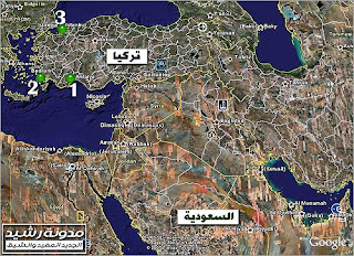
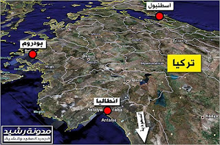
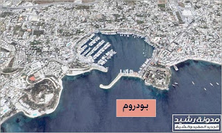
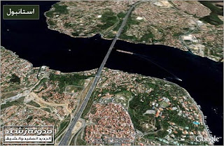
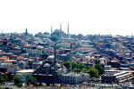
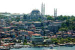
There are three key cities, it attracts most tourists in Turkey, Antalya, Bodrum and Istanbul. To identify the geographic location of these three cities has brought you some images from satellite by Google Earth and you can click on image to enlarge ...
General Information
Of course we known that every country is its own character in many ways, the piece must be certain we have the background for any country before traveling to, and the following points are points of clarification and a section of tips.
• Capital: Ankara
• Official language: Turkish (but can also English-speaking slots)
• Currency: Turkish Lira (and can deal with them in dollars or euros)
• Religion: Islam (99% Muslim, mostly Sunni and Alawite a section)
• Water: preferred not to drink tap water.
• Prices: not cheap especially in tourist areas. Beware of exploitation. (Example: liters of gasoline have the price of SR 7-8 This indicates that the cost of living)
• the nature of people: just like the Arabs in terms of external appearance, religion, their mood is hot and irritable. I mean, if entered the debate with a vendor over the price of a particular commodity may anger you and Atrdek.
• Food: East and familiar to us as Arabs.
• Hotel Rates: For example a journey 4 days, in the tourist season may cost you between 500-900 dollars, while in periods of "weak" might cost you between 250-500 dollars. Of course there are other factors that affected such as the cost of air travel (charter cheap) and the percentage of profit, the tourist agent. Preferred that the reduction in the local agent to take a clearer idea of the prices that may differ in each state.
• Prices at the airport in Antalya: Fantasy, pack a small Coca-Cola costs 40 riyals Saudi, and McDonald's meal costs 100 riyals.
• Insurance: preferred to pay a commission when the insurance agent before you travel tourism, even if I get sick in Turkey and has grown in the hospital, God forbid, you will not have to pay 1400 riyals each night.The most important tourist cities in Turkey
There are three key cities, it attracts most tourists in Turkey, Antalya, Bodrum and Istanbul. To identify the geographic location of these three cities has brought you some images from satellite by Google Earth and you can click on image to enlarge ...


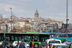
Photos from Turkey and Turkey's tourism map turkey hotels Ankara Istanbul Date and streets, and everything here
Photos from Turkey and Turkey's tourism map turkey hotels Ankara Istanbul Date and streets, and everything here
Turkey (Turkish: Türkiye), officially the Republic of Turkey is a country the greater part of which is located in southwestern Asia and a small part in the South East Europe. Located Bosphorus and Dardanelles straits and the Sea of GPRS, - that link the Black Sea and Aegean Sea up Asia to Europe - in its territory, which makes its strategic and influential countries bordering the Black Sea. Is bordered by Georgia and Iran, Armenia and Azerbaijan in the east, Iraq, Syria and the Mediterranean Sea in the south with the sea border with Egypt, Cyprus, the Aegean Sea, Greece and Bulgaria in the west, the Black Sea to the north.
Turkey was the center of Ottoman rule until 1922, that the Turkish Republic was established in 1923 by Mustafa Kemal Ataturk
The date of
Turkey was the center of Ottoman rule until 1922, and has disintegrated state Seljuk Vtkont the Ottoman Empire in the centuries XIV and XVI and taken to expand even seized control of the Byzantine Empire, Bulgaria and Serbia to stop its expansion following the defeat of Bayezid I (Yıldırım) lightning in 1402 AD, followed period of this defeat and a few political unrest. State regained its balance and continued expansion in the reign of Murad II, and Muhammad the Conqueror, which managed to enter Constantinople in 1453 AD, ending the Byzantine presence in the region. Then passed through stages of the Ottoman Empire was followed by deterioration and degeneration of some of the stages of growth and prosperity, which was soon only a little time until the position remained in the state of decay. The organizations announced the year 1839, a European-style reforms. And ended the Sultan Abdul Hamid II, these reforms in a tyrannical manner, as a result he antagonized the Sultan all the national forces in Turkey. In the year 1922, last sultan was deposed Mohammed VI (Ottoman Sultan and not the current king of Morocco). Finally, Mustafa Kemal Ataturk abolished the Caliphate in the final year, 1924.
Turkey has suffered after the First World War nationalist movement led by Mustafa Kemal Ataturk (ie, father of Turks), and declared Turkey Republic Vetoly presidency in 1923, until his death in 1938, has been able to replace the principles of the Islamic norms of secular nationalist and replaced by writing in Turkey from Arabic into Latin and then his successor after him in power (Ismat Anino) until the year 1950, and took control of civilian rule the country until 1973, and the rule of the military after that date has led to the development of unstable triggering violence in 1980, and the Government of the Turkish opposition to the Kurds and Armenians as the Kurds represent between 20-25 million people and the government does not recognize them as an independent republic, and in 1991, allowed the Turkish President Ozal's resort Kurds to Turkish territory after the revolution in Iraq in 1993, became (Tzlno Ciller) was the first prime minister in Turkey.
Geography
The area of the territory of Turkey 780.562 km and is located 97% of them in Asia and the rest in Europe. Overlooking the west of Turkey on the Aegean Sea and south on the Mediterranean Sea, Egypt, Cyprus and north to the Black Sea. Shared borders eight countries, including Iraq and Syria.
Turkey there are many sources of fresh water rivers and lakes. And more than a third of the area of agricultural land and forests cover more than a quarter of its territory. By mountains and there are many top of Mount Ararat (5137 meters). And control of several islands, most of Turkey in the Aegean Sea and the Mediterranean, the most important Emrouz island (279 square km).
Population
The population of the Republic of Turkey approximately 72 million people according to 2008 statistics. Demographic structure of Turkey and the complex made up of dozens of races, dating to the era of the reasons for formation of the Ottoman Empire, where the areas of influence include a vast territory in Asia, Europe, Africa and the control of many peoples. No official statistics of the number of population by race, because the Turkish government sees Turkey Turks all countries regardless of their ethnic origin, which is not acceptable of all minorities, especially Kurds. According to estimates in this regard, the ethnic Turks, the largest selection of the population (about 70-80%), followed by the Kurds (20-30%), and then Alzazion (a branch of the Kurds speak their own dialect of Kurdish language) (2-3%), Arabs (2%), Circassian (0.5%) and Georgians (0.5%). There are other minorities: Armenians, Greece, Assyria, Arameans, Bosnians, Albanians, Chechens, Bulgarians, to Azion and others. Minorities are Crimean, Tatar, Azeri, Algaghazah, Uzbek, Kyrgyz, Turkmen, Kazakh Turkic minorities.
There are large Turkish communities in the Diaspora, mostly concentrated in the countries of the European Union, where the Turks, for example, the largest foreign community in Germany, with a population of nearly four million people. There are also large Turkish communities in the United States, Canada and Australia.
Age level in the Turkish Republic
Age groups of Turks (2000) 0-4 6033346 Male Female 5-9 6,449,363
10-14 6615428
15-19 6693554
20-24 6390252
25-29 5845812
30-34 5450131
35-39 4759742
40-44 3899599
45-49 3210416
50-54 2453379
55-59 2062228
60-64 1872635
65-69 1513508
70-74 1098952
75-79 720 935
80 + 597,397


The effects of the Spanish city of Malaga, Spain, the real beauty ... Magic strewn
City of Malacca is an old Spanish city located in south of the country and is now the capital of the province of Malacca in Andalusia, has a large bay at the mouth of the River Guadalcanal in the middle of the "Costa del Sol." The most important Spanish port after Barcelona, surrounded by mountains, and Tehran Guadalcanal and Guadalajara, Latif moderate climate attracts tourists to it significantly.
The effects of the Spanish city of Malacca, Spain, the real beauty ... Magic is not strewn Evolute


The effects of the Spanish city of Malacca, Spain, the real beauty ... Magic is not strewn Evolute


ROMANIAN ancient monuments in the State of Algeria

Maximus - Timgad

The public arena Romanian - Timgad

Roman Theater - Timgad

Columns of the Capitol - Timgad

Capitol - Timgad

Arc de Triomphe - Timgad
Romanian tourism


The archaeological research assistant is the only way to interrogate aspects of life in the communities that existed before the invention of writing five thousand years ago. The archaeological research constitutes an important tributary to the enrichment of our knowledge of ancient societies that left written records.
The Archaeology in the Americas, a branch of anthropology (Anthropology); a study of the human race and its heritage of intellectual and physical. According to archaeologists in Europe that their work is closely related to the field of history, archeology, however, is different from the science of history on the one hand, historians studying mainly the march of peoples based on written records.
Archaeologists looking forward to see how it evolved civilizations, and to know the time and place where this development occurred. As well as those looking like Darcy social sciences on the causes of the fundamental changes that have made people in the ancient world, stop fishing for example, and are turning to agriculture. And develop others Atharion theories concerning the reasons that led people to build cities and establish trade routes. In addition, some archaeologists looking for the reasons behind the fall of previous civilizations, the Maya civilization in Central America, and Roman civilization in Europe.
What do archaeologists study?
Archaeologists examine any evidence that could help them to understand the lives of people who lived in ancient times. Range from archaeological evidence of the remnants of a big city, and a few split (cut) stones, left by one who made stone tools since long times.
The three basic types of archaeological evidence are: 1 - Findings made 2 - phenomena 3 - Findings natural. As for the Findings made, it is the man-made materials and can be transferred from one place to another without altering their appearance. It includes items such as arrowheads, pots and beads. Can also involve the community in relation to a history written on clay tablets and other written records. The phenomena consist mainly of houses and tombs, irrigation canals, and many other facilities, built by ancient peoples. Unlike the tools, it can not separate phenomena from its surroundings, without a change in shape. The Findings of natural, they are natural substances that are found side by side with tools and phenomena. Findings reveal the way people interact in ancient times with their surroundings. Findings include natural, for example, seeds and animal bones.
And called the place, which includes the directory name of the archaeological archaeological site. To understand the behavior of people who occupied the archaeological sites, we have to study the relations between instruments made and natural phenomena and Findings, which was discovered at the archaeological site. For example, the discovery of the heads of spears stone near the bones of extinct type of water buffalo at a site in the state of New Mexico, shows that these early human groups, the buffalo hunt in that region.
How archaeologists gather information?
Archaeologists use special techniques and methods for the collection of archaeological evidence collectively accurate, systematic, and keep detailed records on the Findings of archaeological, because the detailed archaeological excavation damage the archaeological remains in question.
Location:
Determine the archaeological site is the first step, which must archaeologist to do. And archaeological sites may be located above ground, as may be underground or under water. Include sites that are under water on the sunken ships, or entire cities flooded as a result of changes have taken place on the surface of the ground or on the water level.
May identify some of the archaeological sites easily, because they see with the naked eye, or can be traced through the descriptions that have been reported in the old stories, or other historical records. And include such sites in Pyramids of Egypt, and the city of Athens in ancient Greece. There are archaeological sites, less clear was discovered by chance people who are not archaeologists, for example, discovered four years to 1940, a cave Aso, in the south-west of France, during their search for their dog. Found in this cave mural paintings dating back to prehistory.
The archaeologists have many important discoveries, and discussed on tirelessly over many years, for a particular site or some kind of sites. In this way discovered the English archaeologist Howard Carter in 1922, the grave is full of treasures for the ancient Egyptian King Tutankhamun.
Archaeologists use scientific methods to find the archaeological sites. The traditional way to discover all the archaeological sites in the region, are from the survey on foot. The archaeologists when they use this method spreading out from each other certain spaces, and walking directions drawn. And everyone was looking for archaeological evidence, the other forward. Archaeologists and uses this method when they want to distinguish the region, which includes archaeological sites from those where there is no such sites. For example, they can use this method, to ensure that archaeological sites exist for a certain region in the tops of the hills and not in the valleys.
And follow the ways of scientific archaeologists to assist in the detection of archaeological sites beneath the surface. The advent of air, for example, shows the differences in plant growth, which in turn refers to the existence of archaeological evidence. Plants in the longer part of the field may be planted over the grave of old, or over an irrigation canal. The shorter plants in the other part of the field, may be planted in the soil above the shallow old building or road. In addition to that used metal detectors, to see if there were metal tools, already buried in the ground at a depth of not more than 180 cm.
Site Survey:
The first stage of the study carried out by archaeologists to a site, is a description of this site. Recorded as these detailed notes about the location of the site, the type of archaeological evidence on the pillar surface. Also took photographs of this site.
The archaeologists mapping for most archaeological sites are discovered. The type of the map drawn on the importance of the site and the objectives of the study and the amount of time and money-extended. And baptizing them in some cases to map after it is simplified the process of measuring dimensions, whether the steps or using a measuring tape. And used in other cases, special tools to clear the archaeological site carefully, and to draw detailed maps to it.
How do scientists explain archaeological monuments Findings?
Archaeologists follow three basic steps in the interpretation of the directory in which they find are: 1 - Category 2 - History 3 - The study and analysis.
Category:
Can archaeologists interpret the archaeological Findings, if they could see patterns of spread of the tools in time and place. To reach these patterns must first classify the tools into groups each group containing Mosurat similar. The Statutes of the classification are: the qualitative and sequential (sequence Trza).
Typology. Materials are classified into groups according to their forms, and methods of manufacture, and functions. And called each of these Findings species. For example, are all similar ceramic pots found in one location, one type, while the other pots are similar from another site another kind.
Category sequential (sequence Trza). Resulted in materials with the same species, all in the series reflect changes in the model. These changes have either been acquired gradually over time, or the result of the spread of civilization in other areas. In many cases, you must know the materials to determine the age of the first and last article in the series.
History:
Archaeologists are different ways to determine the age old and Findings of these methods can be divided into two basic types are: 1 - history of relative 2 - absolute dating.
Relative dating. Trying to figure out some of the Findings presented in relation to each other. That is the way history relative comparisons made do not provide the dates are real. For example, archaeologists can determine the relative ages of the bones that they might find in a site, through this measure them because they contain the bones of the fluoride, because fluoride in groundwater replace other elements in the bones and increase over time. Thus, the older bone age are those that contain more than the amount of fluorine.
Absolute dating. Found limits the age in years. There are many ways to the history of the Absolute. And the way they are used in each case is based mainly on the quality of the material that determines its history.
The most widely used method to determine the history of the ancient remains of plants, animals or human beings is the radiocarbon dating. This method relies on the fact that living organisms are constantly absorbing two types of carbon atoms, two carbon 12 and carbon 14. Called carbon-14 atoms of carbon are also radioactive, the atoms are unstable, and turn into nitrogen atoms. So when an object dies, the ratio of carbon 14 to carbon 12 decreases to a certain degree up to a known rate. As a result, archaeologists can calculate the age of a sample by measuring the amount of carbon 12 and carbon-14 remaining in it. The traditional method used in measuring the precise ages to calculate the age of objects that date back to 50,000 years. The newer technology that use the device known as Bmjl particles, it is an accurate way to calculate the age-old objects that up to 60000 years. This also applies to even the smallest samples. See: radiocarbon; particle accelerator.
Archaeologists use potassium-argon dating to find a certain age of rock formations containing archaeological materials. The rocks containing these radioactive potassium-40, which is converted to a gas argon 40 fixed rate. The scientists measured the amount of each element is then calculated age of the rock. This method has been used to date rock formations and the bones and tools found in eastern Africa. It was found that the age of the rock about a million and three quarters of a million years, suggesting that the bone tools and also of the same age.
The best way known to history is the history of wood rings of trees. These technical workshops on calculating the annual growth phenomenon on the cross sections of trees felled. The archaeologists have matching rings form an old tree, found in the site, with the rings that old wooden materials to determine the age of the site. The history tree rings is the most accurate in all fields of history, but it uses only wood materials that are not older than about 8000 years.
Study and analysis:
Archaeologists study the phenomena and the tools and analysis in order to obtain information such as: how and where they made tools used. In some cases, scientists are acquiring information through direct experience. In the mid-eighties of the twentieth century Atharion of Cambridge in England to rebuild a ship called the Hellenic classical Treram and sailed by. In this way, learned a lot about the shipbuilding industry, the art of navigation in Greek antiquity. And tools and help to interpret the phenomena of social life that existed in ancient times. The size of houses that might indicate the number of people who lived in one house. Indicate the amount of fossils found in the graves and a value, the social class of the person buried.
The calendar Findings natural, exposing information, such as the type of food that people eat and whether they were producing crops or collecting wild plants. Mosurat can reveal natural patterns of ancient migrations.
The archaeologists have archaeological evidence with the assistance specialists in other fields. Hydrologists animal help identify the bones of animals, and methods of slaughter that prevailed. The scientists also analyzed the plant seeds, to obtain information about the agricultural activities of old. The archaeologists also work with other specialists such as geologists, architects and engineers. And then people who specialize in some cases to run the computers that facilitate the evaluation process and accelerate it to a large extent.
Subscribe to:
Posts (Atom)